
Eagle Mountain stands at a modest 2,301 feet above sea level and holds a special place in Minnesota’s natural landscape. This peak lies just 15 miles from the state’s lowest point at Lake Superior, which sits at 600 feet above sea level. Such close proximity creates one of the Midwest’s most distinctive geographical features.
The Eagle Mountain trail challenges hikers with a 7-mile out-and-back trip through dense forest terrain. Roots and rocks crisscross the path leading to Minnesota’s highest elevation point. The mountain may not reach impressive heights compared to peaks in other states, but it has earned its reputation as a worthy destination for outdoor enthusiasts. The peak’s isolation makes it truly remarkable, as 437 miles separate it from any higher ground in North Dakota.
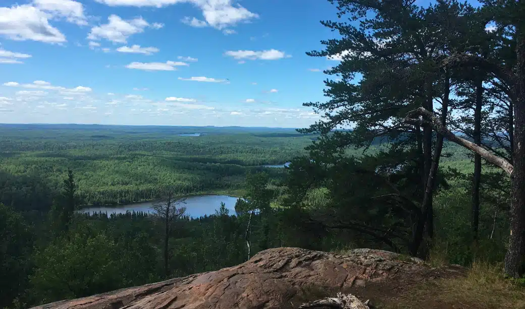
Table of Contents
- 1 Where is Eagle Mountain, Minnesota?
- 2 What to Expect on the Eagle Mountain Trail
- 3 How to Prepare for the Hike
- 4 Personal Reflections from the Trail
- 5 Tips for First-Time Visitors
- 6 Conclusion
- 7 Here are some FAQs about the highest mountain in Minnesota:
- 7.1 How long does it take to hike Eagle Mountain, Minnesota?
- 7.2 What is the tallest point in Minnesota?
- 7.3 What is the hilliest part of Minnesota?
- 7.4 What is the highest elevation in the lower 48 states?
- 7.5 Are there gators in Eagle Mountain Lake?
- 7.6 What is the hardest hike in Minnesota?
- 7.7 What is the 3 highest point in the US?
- 7.8 Why is Minnesota so hilly?
- 7.9 What kind of wildlife lives on Eagle Mountain?
Where is Eagle Mountain, Minnesota?
Eagle Mountain stands 2,301 feet above sea level in Minnesota’s northeastern corner. Nature lovers from all over the state and beyond come to this geographical gem. The mountain might not match up to the Rockies or Appalachians, but it proudly holds the title of the highest point in the Land of 10,000 Lakes.
Location in the Superior National Forest
You’ll find Eagle Mountain deep in the Superior National Forest’s rugged wilderness, in northern Cook County. The mountain’s location is special because it sits right inside the Boundary Waters Canoe Area Wilderness (BWCAW). This pristine wilderness area covers more than a million acres of boreal forest.
The mountain belongs to the rolling Misquah Hills. These hills shape much of the landscape in this remote part of Minnesota’s Arrowhead region. The Superior National Forest and Boundary Waters wilderness come together here. The result is a landscape with remarkable natural beauty and ecological value.
Getting to Minnesota’s highest mountain needs good directions. The trail starts from Highway 61. Turn north onto County Road 4 (Caribou Trail) just north of Lutsen. Drive about 17.7 miles on Caribou Trail – only the first 3.7 miles have pavement. You’ll reach an intersection with Forest Road 170, which locals call “The Grade”. Take a right and drive 3.8 miles to Bally Creek Road. Signs will point you to the Eagle Mountain Trailhead parking area.
Why it’s the highest point in Minnesota
Eagle Mountain might seem modest to mountaineers, but several features make it Minnesota’s highest point. The mountain stands 437 miles from any higher ground, which sits in central North Dakota. Its clean prominence of 1,321 feet makes the peak stand out from the surrounding area.
Eagle Mountain ranks 37th among America’s state high points. The mountain’s location near Minnesota’s lowest point makes it unique. Lake Superior lies just 12-15 miles away at 600 feet above sea level. This creates one of the Midwest’s most dramatic elevation changes over such a short distance.
Nearby towns and landmarks
Hikers planning their Eagle Mountain adventure can find everything they need in nearby towns. Grand Marais, a charming lakeside village, sits about 20 miles southeast of the trailhead. This picturesque harbor town serves as a great base camp with its restaurants, lodging, and supply stores.
Lutsen is another nearby option, roughly 22 miles from the trailhead. The town’s popular Lutsen Mountain Ski Resort adds to the available lodging choices, including hotels, motels, and campgrounds.
The area around Eagle Mountain offers plenty of natural wonders to explore. Whale Lake sits along the trail and gives hikers a scenic spot to rest. Minnesota’s northeastern corner surrounds visitors with pristine wilderness – dense forests, crystal-clear lakes, and rugged terrain that remains mostly untouched.
What to Expect on the Eagle Mountain Trail
The path to Minnesota’s highest point takes you through beautiful wilderness terrain, and rewards you with amazing views at the top. Eagle Mountain Trail gives you a true wilderness experience that tests your hiking skills with natural obstacles throughout the experience.
Trail length and elevation gain
Eagle Mountain Trail stretches 6.6 miles out-and-back and takes about 2.5-3 hours to finish. You’ll climb about 656 feet on your way to Minnesota’s highest point, making it a moderately challenging hike. The complete round trip covers 7 miles from where you start to the summit and back.
Some guides describe the trail as a 10.4 km (about 6.5 miles) loop with 198 meters (650 feet) of elevation gain. Whatever the exact numbers are, you should plan for a half-day adventure when you tackle this iconic Minnesota high point.
Terrain: rocks, roots, and bogs
As you guide yourself to Eagle Mountain Minnesota, you’ll find a wilderness trail that stays true to its rugged nature. The path is quite rocky and uneven, and tree roots criss-cross your way. This mix creates a challenging but authentic backcountry experience.
The first two miles wind through thick forest with little elevation change. You’ll then come across lowland bogs where wooden planks help you cross these marshy spots. These boardwalks protect both the delicate ecosystem and your boots.
The last mile gets tougher and steeper than the rest. The trail becomes rockier here and you’ll need more careful footing. Rainy weather can make parts of the trail muddy and slick, so good hiking boots are a must for Minnesota’s highest point.
Whale Lake and other scenic stops
About two miles in, you’ll find the peaceful Whale Lake, a perfect spot to rest and take in the views. The lake sits at Eagle Mountain’s base and has two campsites – one on the north shore where trails meet, and another a short walk from the west shore.
Whale Lake is more than just pretty – it’s full of northern pike for anyone bringing fishing gear. Walking along the south and west shores, you might think the forested hill ahead is Eagle Mountain. It’s actually a different peak, about 80 feet shorter than your real target.
At Whale Lake’s northwest corner, you’ll hit an important split. Take a left for Eagle Mountain – going straight leads to Brule Lake and deeper into the Boundary Waters.
Summit views and photo spots
At 2,301 feet above sea level, Minnesota’s highest point features a brass plaque on ancient billion-year-old rock. The actual peak sits in a semi-wooded area where trees limit the view, but you’ll find two amazing viewpoints just before the top.
These lookouts let you see miles of untouched wilderness – a beautiful mix of lakes and forests that seems endless. Clear days reveal nearby Shike Lake and Zoo Lake below, plus Eagle and Cascade Lakes in the distance.
The flat ridge near the top makes a great spot to catch the cool breeze and take photos. From here, you can appreciate how close Minnesota’s highest and lowest points are – Lake Superior’s shore (602 feet above sea level) lies just 15 miles away.
How to Prepare for the Hike
Getting really prepared for your trip to Minnesota’s highest mountain will help you have a safe and enjoyable experience. Eagle Mountain sits within the Boundary Waters Canoe Area Wilderness (BWCAW), so you need to follow specific rules and prepare well.
Permits and regulations in the BWCAW
A permit is always required to enter the BWCAW portion of Eagle Mountain Trail. Day hikers can get a free self-issued permit at the trailhead kiosk. You just need to fill out the form, keep one copy with you during your hike, and put the other in the designated box.
The process is different for overnight stays. Hikers must get an overnight permit through recreation.gov (fees apply) between May 1 and September 30. These permits stay with the original holder and only they or their designated alternate can pick them up with photo ID. Groups must stay at nine people or fewer.
What to pack: gear, water, and clothing
Proper packing is a vital part of your day hike to Minnesota’s highest point:
- Navigation tools: A compass and accurate map are essential, as GPS devices can fail
- Water: You’ll need about 1 liter per person per hour of hiking
- Food: Pack energy-dense snacks like nuts, jerky, and energy bars
- First-aid supplies: You need these for any wilderness outing
- Appropriate clothing: Layer up for changing mountain weather
The rocky, uneven terrain of Eagle Mountain Trail calls for sturdy hiking boots with good ankle support. Trekking poles help if you need extra stability. Bug spray becomes absolutely essential, especially in early summer.
Best time of year to hike
Eagle Mountain Trail stays available from April through October, and each season brings its own unique experience[153]. Fall stands out as the best time to visit Minnesota’s highest point. You’ll see spectacular fall colors and deal with fewer mosquitoes and crowds.
Summer hikers should watch out for heavy bug activity, particularly in June and July. During these months, you’ll want a bug head net, long sleeves, and pants. If summer is your only option to hike, treat your clothing with permethrin for extra protection.
The parking lot often fills up on weekends, so weekdays give you a more peaceful experience on Eagle Mountain Minnesota. This timing matters even more during peak fall color season when Minnesota’s highest elevation sees lots of visitors.
Personal Reflections from the Trail
A hike up Eagle Mountain gives you more than just bragging rights for reaching Minnesota’s highest point—it’s an unforgettable wilderness experience that stays with you long after coming down. Stories from hikers who’ve made it to the top help us learn about what makes this trek so special.
Overcoming physical challenges
Most hikers start the Eagle Mountain Trail worried about their physical fitness. “I wasn’t at all sure I could do the 7 miles without hurting,” one hiker said before they ended up finishing the trek. This worry makes sense given the trail’s moderate difficulty and tough terrain.
The trail starts off easy, with a flat 2.5-mile stretch through beautiful forest. In spite of that, the real challenge comes at the end, where you face a steep 500-foot climb packed into less than a mile. This part has earned Eagle Mountain its reputation as “a bit of kick-your-butt kind of hike”.
The good news is that hikers say you can handle the challenge if you pace yourself. “The elevation gain came in. There are steep sections for sure but they’re not that long. And they’re interspersed with long level stretches where I could catch my breath”. Yes, it is common for hikers to reach the summit “more quickly than expected”.
Moments of connection and solitude
Eagle Mountain Trail lets you experience true wilderness solitude. “I marveled at the abundance of quiet and solitude I found in just three and a half short miles”. This peaceful setting creates chances to see unexpected wildlife—from surprising otter sightings to fresh bear tracks on the trail.
Winter brings even more peace and quiet: “If you enjoy solitude, winter is clearly the time to hike Eagle. We saw not one person during our whole hike”. The trail still offers great human connections. Random meetings with fellow hikers like “Craig from Duluth” give you chances to share local tips, spot faraway landmarks together, or swap trail stories.
Why it’s worth the effort
Eagle Mountain may only be 2,301 feet high, but hikers agree it’s special: “Eagle Mountain may not have the height of the Rockies, but it’s got heart—and a hike that’s worth every step”. The trek offers unique rewards beyond standing at Minnesota’s highest point:
- Stunning scenic overlooks show panoramic views of wilderness and lakes
- Seasonal beauty changes the experience, from summer wildflowers to stunning fall colors
- Sense of achievement that enriches hikers’ lives “for years to come”
The trail rewards both quick adventurers and those who take time to notice details. “There is an amazing abundance of plants and wildlife to photograph and find”, including rare flowers like Pink Lady Slippers surrounded by bunchberry blooms.
Eagle Mountain gives you what one seasoned hiker called “a perfect estimate” of the Boundary Waters experience—a taste of wilderness that’s available yet truly challenging.
Tips for First-Time Visitors
A trip to Minnesota’s highest point needs some planning ahead. The path to this summit becomes clearer when you know how to find the trailhead, where you’ll stay, and ways to protect this wilderness area.
How to get to the Eagle Mountain trailhead
The route starts from Highway 61 in Lutsen. Head north on Caribou Trail (County Road 4). You’ll drive 17.7 miles on Caribou Trail, with only the first 3.7 miles paved. This leads to Forest Road 170 (“The Grade”). Make a right turn and drive 3.8 miles. Then turn left when you see signs pointing to the Eagle Mountain Trailhead parking area. Gravel roads will slow you down – the trailhead lies 20 miles from Grand Marais (31 minutes) or 22 miles from Lutsen (33 minutes). The parking area has a Forest Service latrine and day hikers can get permits at the self-issuing kiosk.
Nearby camping and lodging options
You’ll find several places to stay near Minnesota’s highest peak. The Cascade River Rustic Campground sits 2.5 miles from the trailhead, while Devil Track Lake Campground is 6 miles away – both work on a first-come, first-served basis. Cascade River State Park, 16 miles away, lets you book spots ahead. Grand Marais has plenty of hotels like the Best Western Plus Superior Inn and East Bay Suites. Lutsen, about 22 miles from the trailhead, gives you more hotel choices.
Leave No Trace and safety reminders
Eagle Mountain’s preservation depends on following the seven Leave No Trace principles. Stick to marked trails, even through mud, to keep paths from getting wider. Take all your trash, food scraps, and litter with you. The trailhead doesn’t have cell service, so download your maps before the hike. Smart hikers always carry plenty of water, emergency gear, and good shoes.
Conclusion
Eagle Mountain is evidence of Minnesota’s diverse natural beauty and offers nowhere near just being the state’s highest point. The mountain stands at 2,301 feet and gives hikers a genuine wilderness adventure through the pristine Boundary Waters Canoe Area. Many first-time visitors might underestimate this peak based on its height, but the challenging 7-mile round trip quickly shows it’s no easy walk.
The trail definitely delivers a true Minnesota experience up north. Even experienced hikers face challenges from rugged terrain filled with rocks and roots. Whale Lake’s scenic stops give perfect spots to rest and reflect. The summit rewards your hard work with breathtaking views that span miles of untouched forest and glimmering lakes.
Eagle Mountain’s remarkable feature is its location near Lake Superior—Minnesota’s lowest point sits just 15 miles away. This dramatic elevation change over such a short distance creates one of the Midwest’s most unique geographical features. The mountain’s isolation adds to its appeal, with 437 miles between it and any higher ground.
The hiking experience changes with weather and seasons. Fall stands out as maybe even the best time to visit. Vibrant foliage colors the landscape while pesky insects disappear. Summer hikers should prepare for mosquitoes, while winter adventurers enjoy an unmatched quiet.
A successful climb to Minnesota’s highest point needs proper preparation. Day hikers need self-issued permits, the right gear, and enough water. Peak seasons require advance permits for overnight stays.
The mountain might not match the towering peaks found elsewhere, but visitors call their Eagle Mountain expedition worthwhile. The trail gives more than physical challenges – it creates deep connections with nature and chances for both quiet time and friendship with other adventurers.
Eagle Mountain ended up giving everyone a taste of Minnesota’s wilderness that balances real challenge with achievable goals. Standing on that billion-year-old rock with the commemorative plaque beneath your feet captures northern Minnesota’s character: simple yet impressive, modest in height but rich in natural beauty.
Here are some FAQs about the highest mountain in Minnesota:
How long does it take to hike Eagle Mountain, Minnesota?
The hike to Eagle Mountain typically takes 3-5 hours round trip depending on your pace and trail conditions. This trail leads to the tallest mountain in minnesota and covers approximately 7 miles total with moderate elevation gain through beautiful northern Minnesota forest.
What is the tallest point in Minnesota?
The tallest point in Minnesota is Eagle Mountain, which reaches an elevation of 2,301 feet above sea level. This makes it the highest mountain in minnesota and a popular hiking destination located in the Boundary Waters Canoe Area Wilderness.
What is the hilliest part of Minnesota?
The hilliest part of Minnesota is the northeastern region, particularly the Sawtooth Mountains along Lake Superior’s North Shore. This area contains what is the highest mountain in minnesota and features the state’s most dramatic topography with numerous ridges and valleys carved by glacial activity.
What is the highest elevation in the lower 48 states?
The highest elevation in the lower 48 states is Mount Whitney in California at 14,505 feet. This is significantly higher than the tallest mountain in minnesota, which reaches only 2,301 feet, demonstrating the dramatic elevation differences across the United States.
Are there gators in Eagle Mountain Lake?
No, there are no alligators in Eagle Mountain Lake or any other natural Minnesota waters as the climate is too cold for these reptiles. The wildlife around the highest mountain in minnesota consists of species adapted to northern forests like moose, black bears, and wolves.
What is the hardest hike in Minnesota?
The hike to Eagle Mountain is considered one of the more challenging hikes in Minnesota due to its length and rugged terrain. While reaching the tallest mountain in minnesota requires effort, other difficult trails include the Superior Hiking Trail’s most strenuous sections along the North Shore.
What is the 3 highest point in the US?
The third highest point in the United States is Mount Foraker in Alaska at 17,400 feet, following Denali and Mount Saint Elias. This is dramatically higher than what is the highest mountain in minnesota, which stands at just 2,301 feet in elevation.
Why is Minnesota so hilly?
Minnesota’s hilly terrain, particularly in the northeast, was created by glacial activity during the last ice age. The glaciers deposited moraines and carved out the landscape that now includes the tallest mountain in minnesota and the rugged Sawtooth Mountains along Lake Superior.
What kind of wildlife lives on Eagle Mountain?
Eagle Mountain supports diverse wildlife including moose, black bears, gray wolves, white-tailed deer, and numerous bird species. Visitors to the highest mountain in minnesota might also spot smaller mammals like red foxes, porcupines, and snowshoe hares throughout the protected wilderness area.